Plan for the Future:
TCA is leading the next phase of the Community Circuit, refining its route, mapping future connections, and advancing its construction and activation.
Working in collaboration with TYLin and key Fairfax County partners, including the Department of Transportation (FCDOT), Park Authority (FCPA), and Department of Planning & Development (FCDPD). TCA is taking a comprehensive look at how the Community Circuit can best serve residents, workers, and visitors as the area evolves.

This effort focuses on four key goals:
- Documenting existing infrastructure along and near the planned Community Circuit route.
- Identifying proffered improvements associated with development projects anticipated within the next five years.
- Mapping preferred alignments for the Community Circuit that account for planned street grid improvements outlined in the Tysons Comprehensive Plan.
- Highlighting priority segments that should be accelerated by the County or TCA where no nearby development is expected in the near term.
By integrating these components, the project will help guide where and how new trail segments are built, ensuring that the Circuit grows cohesively as Tysons develops. This planning work will also inform opportunities for public realm activation, wayfinding, and amenities that make the Circuit an integral part of daily life in Tysons, connecting people and places across the neighborhood.
Latest Development

Site Visit
As part of the TCA’s continued work to advance the Tysons Community Circuit, the team recently conducted on-site reviews of the planned Community Circuit Route and alternatives, focusing on how future improvements can make the Circuit safer, more comfortable, and more connected for people walking and biking.
In collaboration with Fairfax County and TYLin, TCA assessed current conditions, identified safety and the level of comfort of segments, discussed opportunities for upgrades, and explored potential alignment refinements near Scotts Crossing Bridge and The Mile development. These efforts are helping to categorize the circuit alignments and guide near-term enhancements, such as improved connections, safety features, and placemaking elements, that will strengthen the Circuit’s role as a unifying, active corridor through Tysons.

Alignments mapping:
Working with transportation and planning partners, TCA evaluated existing sidewalks and trails, planned street and infrastructure improvements, and upcoming private development projects. The goal is to identify a clear, continuous route that balances comfort, safety, and accessibility while remaining flexible as Tysons continues to grow. This work helps clarify the interim connection as well as where the future 4.75-mile loop will run and how it can best connect neighborhoods, parks, transit stations, and activity centers.
This alignment mapping effort:
- Identifies where the Circuit already exists and where new segments are planned
- Clarifies which side of the street the Circuit is expected to run along in different locations
- Highlights key intersections and details crossings needed to safely connect segments
- Identifies near-term opportunities to improve gaps and connections before full build-out
The mapping reflects both current conditions and long-term plans outlined in the Tysons Comprehensive Plan. As development occurs over time, this alignment will guide public and private investments, helping ensure that new projects contribute to a connected, easy-to-navigate Community Circuit.
ResourceAlignment Overview
To help guide how the Tysons Community Circuit is built over time, the alignment mapping organizes the route into three categories. These alignments reflect both current conditions and future opportunities, ensuring the Circuit remains continuous, safe, and accessible as Tysons continues to grow.
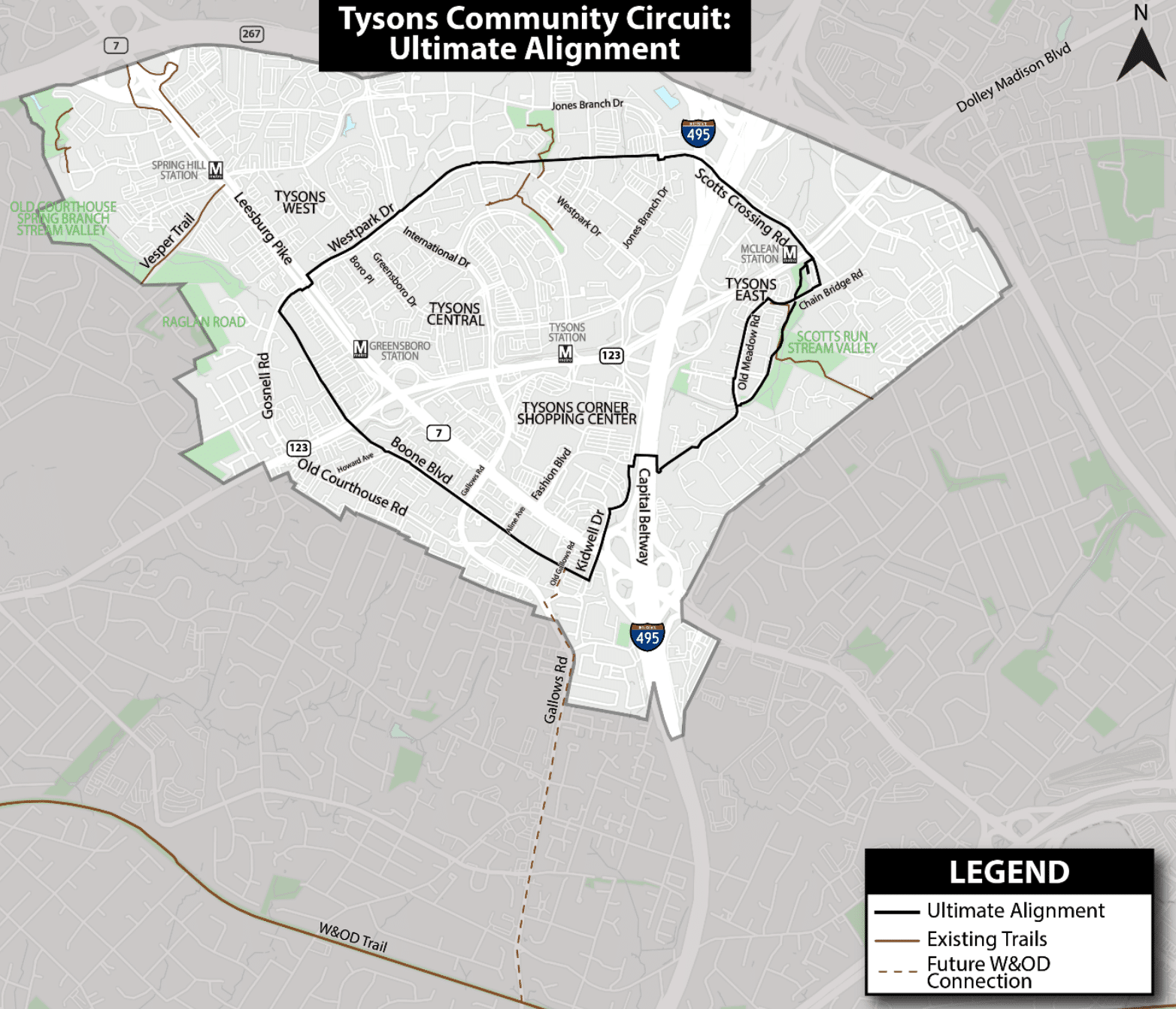
Ultimate Alignment
The Ultimate Alignment represents the long-term vision for the Community Circuit. It shows where the Circuit is planned to run once full build-out is achieved, typically through future street improvements and private development projects. This alignment reflects planned streets from the Tysons Comprehensive Plan and provides a clear roadmap for how new development can contribute to a complete, connected Circuit over time.
Existing and Interim Segment
Existing and Interim Segments include portions of the Circuit that are already built or can be delivered in the near term using current infrastructure. These segments rely on existing sidewalks, bridges, and trails, with targeted enhancements such as wayfinding, pavement markings, and safety improvements. Interim segments help provide continuity and allow people to use and experience the Circuit before permanent infrastructure is constructed.
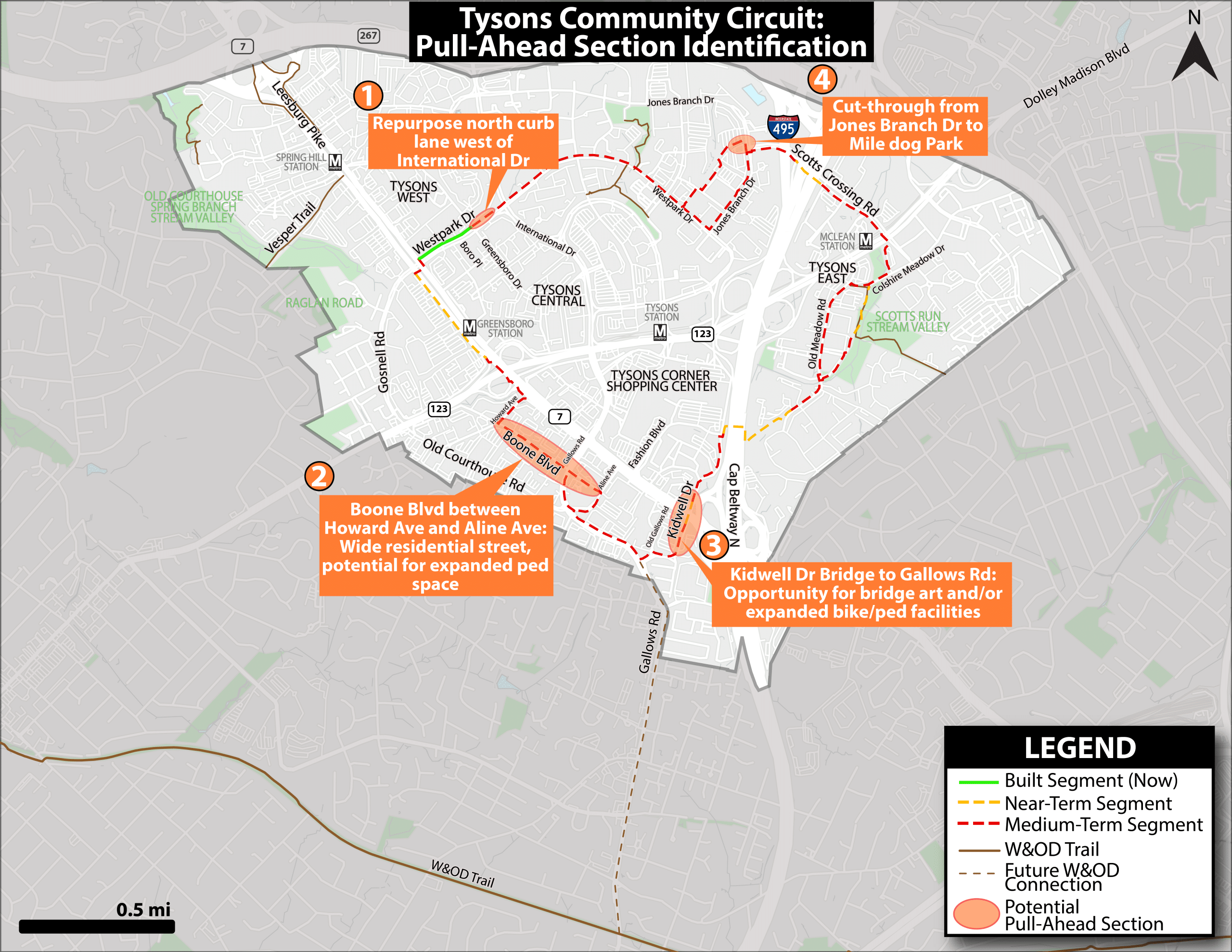
Pull Ahead Sections:
Pull-Ahead Sections identify short, strategic connections that can significantly improve comfort and connectivity in the near term. These sections often address gaps, high-stress areas, or missing links where no development is anticipated soon. Pull-ahead improvements may include short cut-throughs, upgraded crossings, or quick-build treatments and are prioritized because they can accelerate the Circuit’s functionality and usability.
What Exist Today
While the full Tysons Community Circuit will eventually span 4.75 miles, portions of the trail are already complete and open to the public. These early segments give residents, workers, and visitors a first look at how the Circuit connects Tysons through safe, accessible, and enjoyable spaces for walking, biking, and jogging.
Today, 1.15 miles of the Circuit have been completed. Key completed segments include:
Greensboro Segment – Fully built to the official design standards, showcasing the intended look and feel of the Circuit.
I-495 Bridge Segment – Provides a full-width path with high-quality materials, offering a safe and direct crossing over the Beltway.
Scotts Crossing Bridge Segment – A fully built, wide connection supporting both pedestrian and bicycle use.
The Mile (under development) – Identified as a future section of the Circuit, to be completed as redevelopment progresses. A vision for this section has been proposed in plans submitted to the County by the owner.

Community Circuit Design Guidance:
The Tysons Community Circuit Design Guidance provides a unified framework for how the planned 4.75-mile multimodal trail loop will look, feel, and function across Tysons. Developed through a collaboration between Fairfax County and its stakeholders, the guidance ensures a shared identity and user experience.
The design guidance focuses on five key elements that make the Circuit safe, inviting, and easy to navigate:


Intersections:
Intersections are designed with safety and comfort in mind. Each will feature clear paving transitions, accent strips that alert users to crossings, and thoughtfully placed amenities like landscaping. These consistent treatments make intersections easier to navigate and visually appealing.


Crosswalk:
Distinctive, high-contrast crosswalk designs will signal the presence of the Circuit and make crossings safer for people walking and biking. Special attention is given to major roadways such as Route 7 (Leesburg Pike), Route 123 (Chain Bridge Road), and I-495, where visibility is most critical.


Site Furnishings and Amenities:
The Circuit will incorporate comfortable seating, trash and recycling receptacles, and bike facilities, such as repair stations, parking areas, and Capital Bikeshare docks. Water fountains and charging stations may be added where space allows, creating an active and welcoming environment.


Wayfinding Signage
A system of bold, recognizable signage and colorful pavement decals will help users navigate the Circuit and discover destinations throughout Tysons. These elements will tie into the broader Tysons wayfinding and branding initiative, establishing the Circuit as a distinctive “sub-brand” within Tysons.
TCC One PagerHistory
Conceptualization and Foundational Planning:
The concept for the Tysons Community Circuit first emerged in the mid-2010s as part of a broader vision to make Tysons a more livable and connected urban center.
The idea of a multimodal recreational loop, which is a continuous trail designed for walking, running, and biking, was first introduced in the Tysons Park System Concept Plan in 2014. This early framework proposed a conceptual alignment for what would later become the Tysons Community Circuit.
In 2017, The Circuit was formally included in the Tysons Comprehensive Plan and the Tysons Urban Design Guidelines.
The Community Circuit Study and Design Guidance:
Following its early planning phases, the Circuit entered a new stage focused on design coordination and implementation. In Spring 2021, Fairfax County staff and private sector partners identified the need for consistent design standards to guide future development of the planned 4.75-mile trail.
In response, a dedicated Circuit Work Group was established, composed of Fairfax County’s Tysons Core Team and representatives from the Tysons Partnership, TCA’s predecessor.
This collaboration led to the release of the Tysons Community Circuit Design Guidance in December 2022. The guidance established a unified design framework, detailing materials, intersections, crosswalks, site furnishings, and wayfinding signage, to create a seamless and recognizable experience throughout the Circuit.
The Fairfax County Board of Supervisors officially endorsed the Design Guidance on February 7, 2023, marking a key milestone toward implementation.
Implementation Strategy and Current Progress:
Building the Circuit is an incremental process tied closely to Tysons’ ongoing redevelopment. As new projects are completed, each contributes a segment of the trail, gradually bringing the full vision to life.
Of the total planned 4.75 miles, 1.15 miles of the Circuit have been completed and opened to the public.